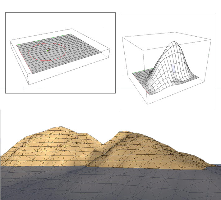
3D modeling has become better and easier after using SketchUp, users can also model Terrain and Other rounded shapes in SketchUp using Sandbox Tools.
Terrain is important thing for many modelers in SketchUp who wants to create a ground to stand on or modeling the ground itself to create a landscape. Terrain can be made by using SketchUp’s Sandbox tools, but it also can create forms completely unrelated to terrain. Though, terrain can include in all these other possibilities because the secret is hidden in the geometry. That’s mean, while modeling terrain or other shapes with Sandbox tools users actually sculpting a special kind of geometry called a TIN (triangulated irregular network) which generally mean “a group of comprised of triangles” .
In this article, we are going to describe the way of start modeling TINs, the path to find Sandbox tools and tell about geolocate TIN.
Getting started with TINs: For creating TIN, users can import contour lines from another program or import terrain from Google Earth through SkethcUp’s built-in tools. Users can also transform contour lines which are drawn into a TIN or may draw a plain flat rectangular TIN. After having a TIN in SketchUp users can toggle terrain between visible and hidden with SketchUp’s layer feature as controlling visibility is the whole reason of layers. After creating or importing terrain, it must be made sure that all the terrain geometry is organized into a single group and then assign that group to layer to control the visibility of terrain. The next step is to sculpt and fine-tine its features by smooving gills and valleys, detailing terrain and flipping edges. The last step is to place other items on its surface.
Enabling the Sandbox tools: To find the Sandbox tools users need to go on the Sandbox toolbar or select Tools>Sandbox and select the tool of choice from the submenu. In SketchUp Pro, the Sandbox Tools are enabled by default. While in SketchUp Make, users also have access to the Sandbox Tools but it needs to be enabled at first.
Geolocated Terrain: While modeling terrain, users can geolocate it or embed geographical coordinates that place terrain at a specific point on the Google Earth. There are a huge number of advantages in the Geolocated models, such as:
- It can study the sunlight and shadows at different times of day and on different days of the year and they both have huge benefits like shadow studies can tell users about if adding a second story in the house will turn a sunny garden patch into a shady place or not. Users can also get an idea of how the sunlight shines into an interior space at different times of day.
- Users can view their models in Google Earth which comes in both free and paid versions that can be downloaded to the computer and it is full of aerial imagery and models. So users can view the model on the site where users plan to build it.
Source: www.help.sketchup.com

- Cover Story
-
 SketchUp Can Help You Win Interior..
 -
 Best Laptops for SketchUp
 -
 How to Resize Textures and Materials..
 -
 Discovering SketchUp 2020
 -
 Line Rendering with SketchUp and VRay
 -
 Pushing The Boundary with architectural
 -
 Trimble Visiting Professionals Program
 -
 Diagonal Tile Planning in SketchUp
 -
 Highlights of some amazing 3D Printed
 -
 Review of a new SketchUp Guide
- Sketchup Resources
-
 SKP for iphone/ipad
 -
 SKP for terrain modeling
 -
 Pool Water In Vray Sketchup
 -
 Rendering Optimization In Vray Sketchup
 -
 Background Modification In sketchup
 -
 Grass Making with sketchup fur plugin
 -
 Landscape designing in Sketchup
 -
 Apply styles with sketchup
 -
 Bedroom Making with sketchup
 -
 Review of Rendering Software
 -
 Enhancing rendering for 3d modeling
 -
 The combination of sketchup
 -
 Exterior Night Scene rendering with vray


