- Sketchup-ur-Space Magazine
-

-

Vision Ai and 3D Urban Modeling
Artificially Intelligent Survey and 3D models Generated on Demand
Artificially intelligent (Ai) software seems to have permeated many levels of our lives. From smart algorithms that control the content we see online to driverless cars. Seemingly ubiquitous, Ai has infiltrated the Remote Sensing sphere.
Ai will now start to impact the architecture, construction and engineering sector (AEC).
Surveying and remote sensing information are required for all AEC projects. Ai collected remote sensing data will now impact 3D modeling users, like SketchUp and Revit.
Remote sensing
Remote sensing is the scanning of the earth by satellite or aircraft in order to obtain information about it (source Wikipedia). The collected remote sensing data, like aerials, DEM’s, DTM’s, contour maps, building footprints and heights (Figure 01) etc. serve as necessary starting points for orienting and understanding a project site.
 Figure 1: DTMs, contour data, aerials, all form the backbone of site project information and start up. Images courtesy of DHM Design / Daniel Tal
Ground survey’s
Ground survey’s, manually collected by people in the field, is used alongside remote sensing data. The combined information yields 2D CAD base files (Figure 02) of existing conditions for both above ground and underground existing conditions, like utilities, curb and road layouts, site features like street lights, etc…
 Figure 2: CAD DWG files are core files for developing a site design. They require manual drafting by an operator to create. They include survey information locations and existing conditions. Images courtesy of DHM Design / Daniel Tal
Most projects experience several weeks to months delay from a project start and when the site survey and remote data is available. This slows down the initial design process, forcing many companies to rely on third party vendors like Google Earth, to just get a basic aerial of a location. Drones, another disruptive technology, do fill the gap for many projects, allowing firms to obtain some of the data on their own (Figure 03). That still requires a person on site flying the drone then going back to the office and processing the data.
 Figure 3: Drone data and images are powerful accessible tools. Used for concept development, 3D renderings can be merged onto a drone image for clear context and understanding of design intent. (Existing conditions on the left, model concept overlay on the right). Image courtesy of DHM Design / Daniel Tal
But to obtain a 2D cad file of existing conditions (figure 02) requires time and drafting labor to produce. It is a manual process regardless of who completes the task be it a surveyor, draftsperson or designer.
Computer Vision Ai
Artificial Intelligence, specifically those related to computer vision identification or vision ai, are revolutionizing this traditional paradigm described above. Computer Vision has been around for a while.
More commonly used for facial recognition software and easily accessible to the average coder wanting to develop apps utilizing computer vision; usually for identification of a product, item, location, animal, flora, and not least of all driverless car’s navigation. (Figure 04)

There are many companies now using vision ai to scan the world, resulting in Ai derived remote sensing and surveying data produced quickly and for substantially reduced costs. Common examples include the updated data on Google Earth (and maps) and Bings online portals.
One company, Ecopia Tech (Figure 05) is at the fore front of this revolution. Using high resolution aerials, Ecopia has trained smart vision ai software to identify, classify and segment site features on an aerial. Not just outlines or blobs but accurate lines defining almost all the features found in the built world: Curbs, gutters, street lights, man holes, building footprints, parking areas, driveways, trails, ped lights, etc..
 Figure 5: The image shows a DWG / CAD (bottom) and SketchUp surface model (top) generated from Ecopia Tech vision Ai information. PlaceMaker (full disclosure, the author is one of the owners) process the data for SketchUp and CAD specific file formats. The data includes accurate curb, gutter, concrete, asphalt surfaces, building footprints and more.
 Figure 6: Ecopia can produce a variety of data from an aerial. The rotating gif shows some of the typical data set.
The process is simple to explain. Ecopia takes an aerial with good quality (7cm resolution is ideal), uses their trained ai algorithms which then creates outlines, layers and useful 2D CAD and 3D modeling line work, areas and delineations (Figure 06 and Figure 07)
Ecopia has been training these smart vision ai detection systems since 2009. The first step was training the computer to identify all the various site features. Now Ecopia is in the process of developing data sets for specific locations including the entire US, Canada, Western Europe Australia and more. Some locations are already available on demand. Other locations require a one month turn around. But in the coming future the process of creating coverage specific data will include whole swaths of the globe (think like Google Earth). The AEC industry, real estate, cities and counties, corporations and more will have this data at their fingertips for a fraction of the cost.
Currently, SketchUp and Revit users can obtain this data through PlaceMaker (www.suplacemaker.com) who serves as both reseller and file converter for end users. Full disclosure, the author is one of the owners.
Through PlaceMaker, Ecopia provides several output formats useful for AEC. The provided Ai generated survey can be easily converted into SketchUp, DWG or similar formats (this is what PlaceMaker does).
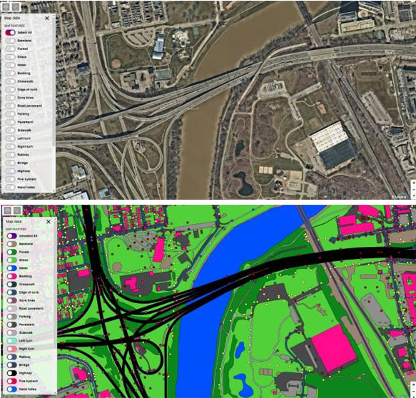
 Figure 7: Ecopia Tech takes a high-resolution aerial (top) and processes the various ground elements and objects producing a vector line work (middle). The results are CAD and SketchUp files that accurately delineate site features, walks, curbs, planting areas, etc. The cost is $1000
Unprecedented
For the first time in almost 4000 years, the human is removed from the drafting process of a site survey. The manual drafting process is replaced by an automated intelligent system. This saves huge costs.
Consider, Ecopia provides 1 square KM of data for $1,000 USD. A manual survey done, with people on the ground and using manual digital drafting would cost hundreds of thousands of dollars if not more for the same area.
The animation below is an example of what this data looks like in SketchUp and Revit. 3D massing models (OpenStreetMap buildings also imported using PlaceMaker) combined with the Ecopia site data is in the closest thing to an instant site model of existing conditions available. In the video 3D massing models from PlaceMakers OSM data set are included. All the roads, open spaces, driveway, parking, bridges, open space, park space, i.e. a fully classified articulated 3D model of existing locations.
 Figure 8: Ecopia data in SketchUp. The entire data set is affordable and ready for modeling. Combined accuracy with savings in labor make this almost a necessary step for obtaining data for projects.


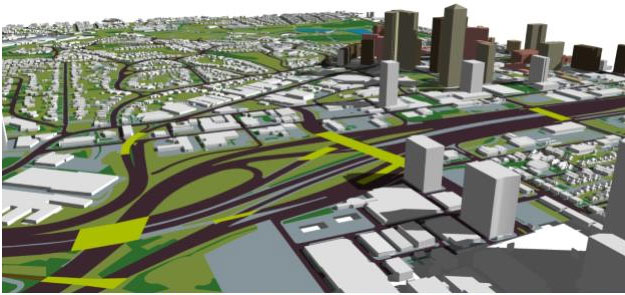 Figure 5The Ecopia survey in SketchUp can be fully edited and added to. PlaceMaker is able to deliver the Ecopia data in useable, tagged SketchUp and DWG formats.
More than just survey
Ecopia visions ai does not stop with a general survey of a site. Currently Ecopia is creating building volumes with accurate heights and articulation. The goal is to further texture these buildings into more accurate representations of reality.
And upon request, the aerial data can be further parsed to specific parameters. Down to the manhole, pedestrian light, tree and traffic light (Figure 09).
This is just the beginning. What comes next over the next five years will quietly revolutionize yjr way AEC project can be started and delivered through a project life cycle. Consider that companies like Google and Microsoft already have this level of accurate data for their use. Accessing this data from big tech is almost impossible to obtain. Companies like Ecopia and Nearmap are paving the way for easier access to accurate information that is also updated frequently enough, keeping it relevant.
The costs, the coming on-demand availability (and in some locations, already available data) will allow SketchUp and Revit users to quickly build detailed accurate models for design.
Daniel Tal, ASLA

Daniel Tal is a landscape architect with over 20 years of experience. He is the visualization and technology manager for DHM Design. He trains staff in the use of SketchUp, Lumion, geospatial programs and drones. Daniel also owns an operates PlaceMaker (www.suplacemaker.com) along with Dale Martens from mind.sight.studios. Daniel is working on other apps for SketchUp including UrbanPaint(www.sketchurbanpaint.com). Daniel writes and lectures on 3D modeling. He published the books Google SketchUp for Site Design and Rendering in SketchUp. He has a forthcoming book, Drones in Professional Practice, coming out in early 2021. Daniel provides free and for pay SketchUp videos at www.danieltal.com and lectures across the country on technology.

- Sponsored Plugins


- Sponsored Plugins

- Sketchup Tips & Tricks
-
 SketchUp Now Handles..
 -
SketchUp Now Handles..
-
How Can You Make..
-
Virtual Design..
-
Adding SketchUp Models..
-
August Update Rolls..
-
ArielVision vs IRender nXt..
-
How to Supercharge..
-
Top 10 SketchUp Plugins..
-
RpTreeMaker plug-in..
-
FredoTools Sketchup Plugin
-
MIO PlasticForms - 3D..
-
Revisiting SketchUp Pro..